
Maps and lists of names
Nicholas Zharkikh
Shortened text of the section.
Full text in ukrainian version.
Our valiant army expelled the Muscovites from Kherson!
The event we have been waiting for since late February 2022 has finally happened! Our victory in the war against the Rotten Straw Horde is approaching!
This inspires me to continue my work (November 15, 2022 at 8:50).
Map of Fra Mauro (c. 1450)
Let’s now look at the territory of modern Ukraine:
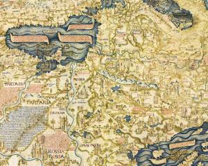
Ukraine on the map of Fra Mauro
fragment of a scan from Wikipedia, north – below
Here we see the Dnieper, flowing in a general course from north to south. The map shows a large bow of the Don, but there is no similar large bow of the Dnieper. This is a major flaw in the map.
Due to the small scale of the map and the author’s limited knowledge of the region, it is more useful for the history of cartography than for familiarizing yourself with the geographical realities of our lands in the 15th century.
Portolan of Grazioso Benincasa (1470)
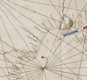
Northern Black Sea Region on the portolan of G. Benincasa
As we can see, this is a classic portolan, only objects on the shore are marked, no objects in the depths of the mainland are marked.
"Map of Nicholas of Cusa" 1491
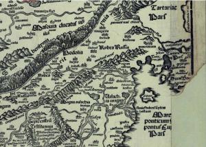
Territory of modern Ukraine
on the "map of M. Cusa" of 1491
It is immediately clear that this map, although engraved in Italy, is not at all dependent on the Italian cartographic tradition. The map is oriented to the north, Jutland is depicted here as a peninsula, and its southern edge generally runs through the Alps. Therefore, it is possible to believe that the map was drawn somewhere in Germany.
A consideration of the territory of Ukraine and Eastern Europe on this map shows the difficulties the author was in, who had to be the first, without predecessors, to draw a territory he knew very little about. The map is simply full of errors, which tell us that the author had some kind of geographical description with the names of objects, but could not deduce their location from it.
Two conclusions can be drawn:
1. This map cannot to be a source for the study of 15th-century Eastern Europe.
2. This map maybe to be a source for the history of the accumulation of geographical knowledge about Eastern Europe.
Not long ago I asked myself question: do our allies really think that one battalion of Abrams tanks is enough to defeat the Rotten Straw Horde?
The question seemed rhetorical to me, but it turned out that there are American generals who really think so. For example, General Hodges, who is simply called "Ben" (his name is actually Frederick Benjamin). He served as an adjutant, only for two years he commanded a brigade and for three years he commanded US forces in Europe. He participated in two unsuccessful wars for the US – in Iraq and Afghanistan. I don’t know if Hodges was personally guilty of those defeats. Victory has many fathers, but defeat is always an orphan…
And here is this general, who has never won a single war or even a decent battle in his entire life – took up teaching Ukraine’s leadership that it is necessary to lower the mobilization age, recruit as many people as possible and wage a "meat war." Also Associated Press spread misinformation by own work on the same topic (of course, with a "reference" to an anonymous White House official, but I have such "sources" too).
What’s wrong? The Muscovites are waging a meat war and are advancing little by little, so the Ukrainians should do the same.
But why is this "simple math" silent about three thousand modern aircraft for Ukraine? About three or five thousand Tomahawk missiles? After all, about three thousand tanks?
Yes, because these weapons cost American taxpayers’ money, but the lives of Ukrainian soldiers cost Americans nothing (December 7, 2024 at 9:26).
And for dessert: US President Biden’s National Security Advisor Jake Sullivan said that the Abrams tanks transferred to Ukraine were understaffed and not very useful on the battlefield. As they say, neither add nor subtract! (December 8, 2024 at 12:25)
Lists of geographical names of the 15th century
Currently, three such lists are known: “List of Švitrigaila’s Towns”, compiled in Vitebsk in 1432, “List of Rus’ Towns”, compiled in Veliky Novgorod in the middle of the 15th century, and lists included in the jarlyks of the Crimean khans (15 of them are known – from 1461 to 1574). I have devoted separate works to all of them. [Zharkikh N. I. «List of of Švitrigaila’s Towns": order and disorder. – K.: 2024; "List of Rus’ towns": clear and unclear. – K.: 2024; Geography of Crimean jarlyks of the 15th and 16th centuries. – K.: 2024]. Here it is briefly.
As we can see, only Cherkasy is present in all three lists. Dashiv appears in the jarlyks only from the beginning of the 16th century. There is no simple connection between these lists.
They all add very little information to what we knew without them.