Rubruk's geograpical discoveries
Nicholas Zharkikh
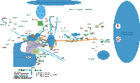
Description of Rubruk's travel is sufficient detailed so one can try to draw an outline map. First map reflecting the geography of Eurasia, mainly based on Rubruk, without the use of modern topographical base. It should be noted that some elements of the map are based on modern geographical knowledge, as Rubruk's text data not enough for their graphical display.
Map of Eurasia by Rubruk's description
Map displayed some false geographical representation of Rubruk.
1. Caspian Sea he calls Sea Sirsan and explains that the name of the city which lies on the shore of the Sea in Persia. Sirsan is a slightly distorted Shirvan, there is no such city on the Caspian shore. This is actually the name of the historic area (northern part of Azerbaijan).
2. Mulihec mountains Rubruk placed on the eastern shore of the Caspian Sea, and stresses that this sea on three sides (except north) is surrounded by mountains. The name comes from the Arabic "mulkhyd" (heretic), as the orthodox Arabs magnified Ismailites. The core of their phantom state located in the mountains Elburs on the south rather than east coast of the Caspian Sea – where Rubruk places the Caspian Mountains. I think that the Mulihec mountains – is erroneous doubling of Caspian Mountains (Elburs).
3. Tian Shan Mountains Rubruk considered to be continuation of the Caucasus and thought that they reach the coast of the Caspian Sea, as reflected in the outline.
4. Describing the northern Black Sea Rubruk indicated that Wallachia and minor Bulgaria lie beyond the Danube, that is, on its right bank. This contradicts with geographical notion of later time, according to which Wallachia situated on the lower left bank of the Danube, and Bulgaria – on the right.
Having outlined Rubruk's geographical errors, it would be very unfair not mention his great merit to Western geography. These merits can be formulated as:
1. Rubruk gave a very detailed description of the steppe zone of Eastern Europe, including landscapes, natural resources, information about ancient peoples and of changes in resettlement after the arrival of the Tatars.
2. He gave a description of the Volga, the first Europeans had visited the city Saraj. He correctly determined that the Volga flows into the Caspian Sea (no joke – in the early 16th century M. Miechowsky in his "" erroneously wrote that the Volga flows into the Black Sea).
3. Rubruk correctly pointed out that the Caspian Sea is not a bay of the ocean, and quite accurately defined its perimeter.
4. He gave a detailed description of the lands of modern southern Kazakhstan, presented information about Lake Balkhash.
5. He gave a detailed description of the Karakorum, which was the main source of our knowledge on this city.
6. He submitted a description of lands and peoples neighboring Mongolia. This description contains the most fantasies (which in general very little in Rubruk), but these were the first since ancient times news of China and neighboring nations, which came to Western Europe.
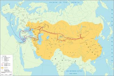
The second map shows the path of Rubruk's travel on a modern topographical base.
Map of Rubruk's journey in 1248 – 1255
Map prepared in 2012 by D.V.Vortman
for which I express my sincere gratitude to him.


