Back way
Nicholas Zharkikh
On the way back from Karakorum to Batu's court Rubruk does not give any details that would be rendered to the localization. Way from Karakorum to the Volga between 47 th and 48 th parallels has a length of approximately 4200 km, but it leads through the central Altai highland. I think this route is impossible, and I assume that Rubruk rounded Mongolian Altai in the south, about repeating his way forward, and then, traveling through Dzungarian Gobi, began to withdraw to the north. Further to the west were two passages – north and south of the Tarbagatai ridge. Which of them rode Rubruk – can not be established, both of them lying north of Lake Balkhash.
Somewhere here, in my opinion, he drove past court of Ken Khan (Güyük). Other sources do not provide evidence of its location, so we can not use this landmark for precising route. Instead, Rubruk's mention contains a single instruction (albeit very vague) on the location of this object.
Then he could go directly to the west along the 50th parallel (at the latitude of Karaganda and Aktyubynsk). In general, this route is about 4850 km lying north of the one Rubruk rode east. This way he traveled for 70 days, giving an average speed of 69 km per day.
Rubruk arrived in Batu's court one year after he went out of it – September 16, 1254. But we have to assume that court at this time was far north of its location last year. Why?
Leaving from Batu, Rubruk 15 days went to Saraj (near the modern village Selitrene on Akhtuba). During this time he drove no less than 450 km, that he went somewhere from district of Yeruslan river (left tributary of the Volga). But before he traveled a month along with Batu's court – perhaps to the south. Hence the northern placing of court at the moment of Rubruk's arrival.
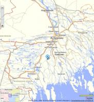
Leaving from Saraj, Rubruk visited mysterious city Summerkent in one of the middle Volga sleeves. Recently it was suggested (Article , 2011) that Summerkent was a site near the village Samosdelka south of Astrakhan, 120 km south of Saraj (see map). Archaeological research found that the settlement has a strong cultural layer of Golden Horde time. If Rubruk indeed visited it, how could he get there? Easiest way to get from Saraj to this settlement – sail sleeves Akhtuba and Volga. Rubruk neatly noted that he crossed 7 sleeves of Volga, but never mentioned that he sailed on it. So, the way by water should be deleted. If one go from Saraj to the south by left shore of Akhtuba and then in the delta area get the south-west course through the Volga delta, there are much more sleeves than seven, but couple of dozen. And a lot of sleeves must be overcome to get out from Samosdelka settlement to the mainland right bank of the delta.
For these reasons, I find it difficult to agree with this assumption. The number of sleeves that crossed Rubruk shows that he cross the Volga River above the delta beginning. It also indicates the width of the valley, where flowing sleeves – 7 Leagues, which generally agrees with the width of the valley above the beginning of the delta (20 – 25 km). The width of the delta is much larger, and delta was not described by Rubruk.
Next Rubruk 12 days went to the Iron gates (Derbent). Distance from Saraj – 600 km, the rate of movement – 50 km per day.

